Mod 2: Assignment 4
In this exercise we were instructed to create a map to a destination we would like to go to based on a mapquest image. The location I chose to use was the Orange Bowl, a stadium in Miami, Fl that hosts the resurgent Miami Hurricanes NCAA football program. This is the last year the team will play at this location, moving to a new facility next year. The orginal map can be located here: http://www.mapquest.com/maps/map.adp?latlongtype=internal&addtohistory=&latitude=uYll9c%2bA%2biKNb2UOVpEqUA%3d%3d&longitude=rjVDKAlQ3vicDxLphKFaeg%3d%3d&name=Miami%20Orange%20Bowl%20Stadium&country=US&address=1501%20NW%203rd%20St&city=Miami&state=FL&zipcode=33125&phone=305%2d643%2d7100&spurl=0&&q=orange%20bowl&qc=Stadiums%20Arenas%20%26%20Athletic%20Fields#east
The .gif image below is the map that I rendered (although not well) noting the location in the center in green. The green/orange "U" above the location is the logo of the Hurricanes. The red ellipse denotes the entrance to the facility. 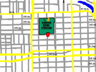
No comments:
Post a Comment